Day Hikes around Echo Summit and
the Crystal Basin
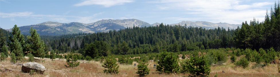
An abundance of scenic day hikes greet visitors along the Echo Summit corridor. Among the most popular areas for day hikes are Echo Summit and the Crystal Basin. The Desolation Wilderness is accessible from both Echo Summit area and Crystal Basin. Even for a day trip into the Desolation Wilderness you will need a permit, but they cost nothing and are easily obtained at self-serve kiosks at most of the popular trailheads or at ranger stations.
We show here our favorite hikes, ranging from casual strolls to full day-long adventures.
Horsetail Falls
Echo Summit Area Day Hikes
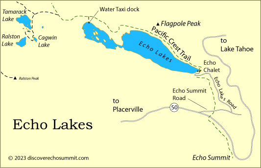
Echo Lakes
Trailhead: Echo Lakes
Distance: 2.5 miles one way
Elevation changes: +200 feet (7,400' - 7,600')
This easy hike along the shores of Echo Lakes offers ever changing views of the lakes. Much of the shoreline is taken by private cabins, but they are often hidden among the trees. You can bypass the return hike by taking the Echo Chalet Water Taxi" target="blank">Echo Chalet Water Taxi from the upper end of the lakes. Extend your hike 1.25 miles to Tamarack Lake if you like.
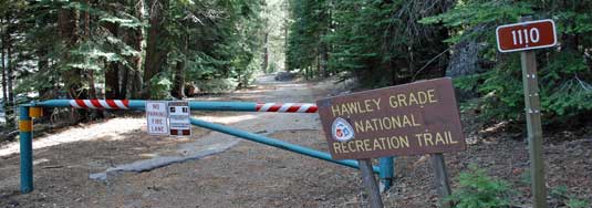
Hawley Grade National Recreation Trail and
Upper Truckee Falls
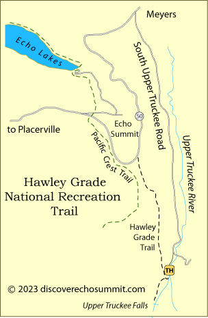
Trailhead: South Upper Truckee Road, Meyers
Distance: 2 miles one way
Elevation changes: +750 feet (6,500' - 7,250')
Hike along the old Pony Express route from Meyers to the top of Echo Pass, gaining views of Lake Tahoe as you climb. Add to your adventure by including a side trip out to view the Upper Truckee Falls.
To find the trailhead, drive out South Upper Truckee Road (off Highway 50) for 3.7 miles and look for the turnoff for the trailhead. If you are bound for the falls first, after only a short distance on the Hawley Grade trail, take the left turn trail and hike a mere third of a mile up the river to the falls, best in the spring. The right-hand fork climbs steadily to the top of the pass. Along the way watch for another small waterfall, usually dry by mid-summer.
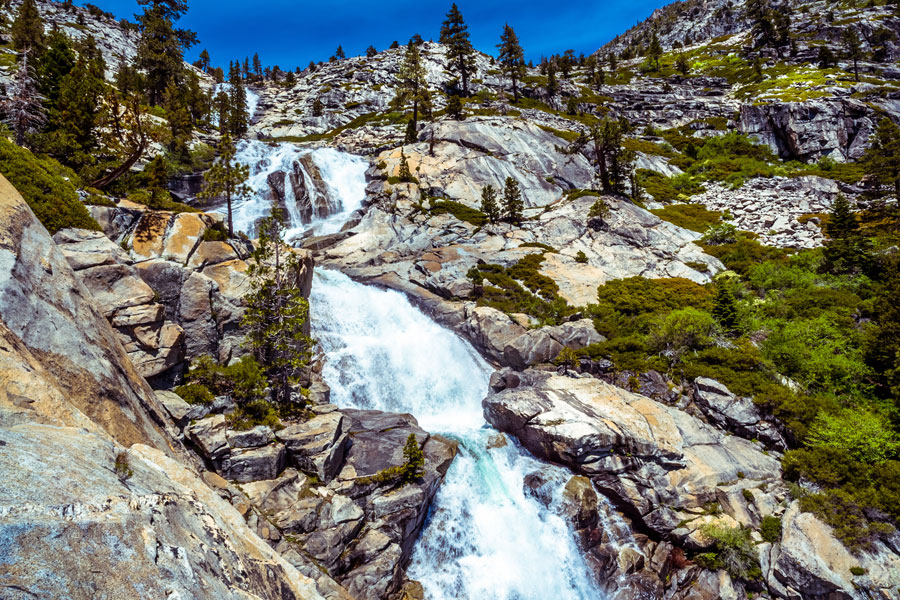
Horsetail Falls
Sections Currently Closed (2023) - Check for Updates: Eldorado National Forest
Trailhead: Twin Bridges Pyramid Creek Parking Lot, $8 parking fee
Distance: 1.5 miles one way, trail and scramble
Elevation changes: +1,300 feet (6,100' - 7,400')
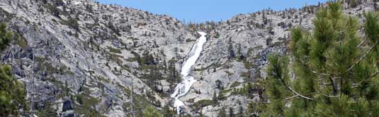
Five-hundred-foot-tall Horsetail Falls is one of the most spectacular sights along the Echo Summit corridor. The Twin Bridges parking lot is often crowded in the summer. From the parking lot start up the Pyramid Creek Trail. Soon you arrive at a divide in the trail, the beginning of the Pyramid Creek Loop. Either trail will take you to the Horsetail Falls Trail.
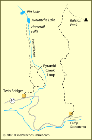
After a mile you arrive at the junction of the Horsetail Falls trail into Desolation Wilderness. There at a kiosk you pick up a free day hiking permit to enter the wilderness. The trail up to the top of the falls is not well maintained. In places, especially near the top, you will be scrambling over and around boulders and crossing granite slabs. Extra caution should be used along this portion of the trail.
Ralston Peak
Trailhead: Highway 50, across from Camp Sacramento, one mile east of Twin Bridges
Distance: 3.2 miles one way
Elevation changes: +2,735 feet (6,500' - 9,235')
The 3 mile climb to the top of Ralston Peak rewards you with spectacular views all the way to Lake Tahoe and across the Desolation Wilderness. Since you will be entering the wilderness, be sure to pick up a day hiking permit at the trailhead (free).
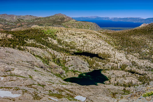
View from Ralston Peak
Be sure to carry plenty of water on this very strenuous hike. The trail heads north up the ridge east of Horsetail Falls. At the top of the ridge, look for an obvious use trail leading southeast to the summit of Ralston Peak. Numerous cairns (ducks) mark the route over fairly easy terrain. The final little stretch is up a talus slope to the summit.
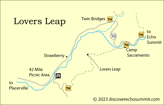
Lovers Leap
Trailhead: Near 42 Mile Picnic Area or Camp Sacramento Trailhead
Distance: 1.5 miles one way
Elevation changes: +1,000 feet (5,900' - 6,900')
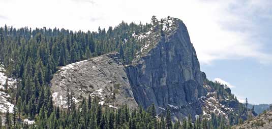
Lovers Leap towers more than a thousand feet over the American River Canyon near Strawberry. The peak is a popular destination for rock climbers. You can approach it from the west by taking the turnoff to 42 Mile Picnic Area just south of Strawberry, then Packsaddle Pass Road to Strawberry Canyon Road and the trailhead. The trail climbs 1000 feet in 1.5 miles.
To hike from the east, take the Camp Sacramento turnoff from Highway 50 just east of Strawberry. Look for the Lovers Leap trail head parking soon after crossing the bridge. This 1.5-mile trail climbs only 600 feet. The first mile is very gentle while the last quarter mile is quite steep.
Crystal Basin Day Hikes
Beauty Lake
Trailhead: Wrights Lake, Rockbound Trailhead
Distance: 0.5 miles one way
Elevation changes: +100 feet (6,950' - 7,050')
It is an easy walk out the Rockbound Trail to Beauty Lake. If you want to turn it into a longer outing you can make a loop around Wrights Lake (2.6 miles total) by turning onto trail 16E15 which leads around the north side of Wrights Lake and south to some cabins along the lake's east shore. Then follow dirt and paved roads around the lake to your starting point.
Sun Rock
Trailhead: Van Vleck - Tells Peak Trailhead
Distance: 2.2 miles one way
Elevation changes: +250 feet (6,200' - 6,450')
Start out the Bassin Loop trail for 0.7 miles where you will meet the Sun Rock Trail to your right, heading west. The easy trail will lead you to the southern base of Sun Rock. Return the way you came.
Gerle Interpretive Trail
Trailhead: Gerle Creek Campground at Gerle Reservoir
Distance: 0.7 miles one way
Elevation: +80 feet (5,280' - 5,360')
The Gerle Interpretive Trail lead upstream along Gerle Creek. Cross the creek on a metal bridge and follow the trail around the east side of the reservoir to the Angel Creek Picnic Area. The trail is wheelchair accessible.
Harvest Interpretive Trail
Trailhead: Angel Creek Picnic Area at Gerle Reservoir
Distance: 0.7 miles one way
Elevation: +40 feet (5,220' - 5,260')
The Harvest Interpretive Trail begins at the picnic area and leads around to the western shore of the reservoir. Signs along the way describe how Native Americans gathered food in this area. You will also see large pine and fir trees and cross a boardwalk over a marsh and a bridge over a small creek.
Ice House Bike Trail
Trailhead: Ice House Reservoir
Distance: 3.1 miles one way
Elevation: +80 feet (5,400' - 5,480')
This dirt trail can be accessed from any campground on Ice House Reservoir or from the intersection of road 12N06 and Ice House Road (200 yards north of the turnoff to Big Hill Lookout). The trail winds along ridge tops and shaded northern slopes, through dense old growth forest and young tree plantations. There are excellent views of Ice House Reservoir and a few peeks of the Crystal Range through the many trees. The west end of the trail connects to the extensive road system around Big Hill and the east end connects to the road system east of Ice House Reservoir.
Other Passes - Other Hiking Trails
Donner Summit

At the north end of Lake Tahoe around Donner Summit (Interstate 80) are many great day hikes. Some lead out along the Sierra crest, others to nearby lakes. The Donner Lake trails are easy and beautiful. For all the best day hiking trails, see Around Donner Summit.
Carson Pass
Drive south on Highway 89 out of Meyers and arrive at the Hope Valley on Carson Pass (Highway 88). Or take the Mormon Emigrant Trail Road south from Sly Park. Discover the great hiking trails around Carson Pass, Caples Lake, Silver Lake, and Blue Lakes. For information on Carson Pass, see Up and Over Carson Pass.
Ebbetts Pass
A little farther south you find dramatic Ebbetts Pass (Highway 4) with hiking trails around beautiful Lake Alpine and out at Spicer Meadow Reservoir. Down near Arnold you can hike on the new Arnold Rim Trail. To learn about all the great hiking on Ebbetts Pass, see Ebbetts Pass Adventures.
Sonora Pass
Sonora Pass (Highway 108) is the gateway to the Emigrant Wilderness. A number of enjoyable day hikes lead out of places like Kennedy Meadows, Leavitt Meadow, and Pinecrest. Learn all about them on Sonora Pass Vacations.