Desolation Wilderness Permits
The Desolation Wilderness is by far the most popular destination for backpackers in the Echo Summit area, which is why the wilderness has among the strictest permit regulations in California. In order to protect its unique beauty and wilderness character, human access is limited and certain activities are restricted in the Desolation.
Nevertheless, once hikers understand the rules and procedures, it is easy to plan a trip and obtain a permit. At peak times, competition for the limited number of available reservations for some overnight permits may seem to be a hurdle, but with a little flexibility in your itinerary, you can plan a rewarding trip into Desolation. Be sure to check the table of zones and quotas and the zone map below.
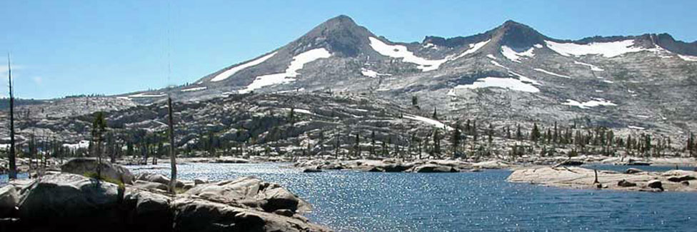
Velma Lake
Desolation Wilderness Permit Information
Who Needs a Permit?
Any person entering the Desolation Wilderness at any time of year needs a permit, even day hikers. Day hikers simply pick up a permit at a ranger station or at most of the popular trailheads at self-serve kiosks. There are no charges nor quotas for day visitors, although a couple of trailheads charge a fee for day parking (but not for overnight wilderness permit holders). Anyone staying overnight in Desolation Wilderness needs a Wilderness Permit which must be obtained on-line or picked up at a ranger station before your trip.
Permit Reservations
Quotas limit the number of overnight visitors who plan to camp their first night in a particular wilderness zone. There are 45 zones. Quotas are in effect Friday before Memorial Day weekend through September 30. Permits are still required at other times of the year.
Seventy percent of all overnight permits are available by a computerized reservation system at Reservations.gov - Desolation Wilderness Permits. Or you can call (877) 444-6777. You can make your reservation up to 6 months in advance. Then within 14 days of your trip, log back onto your account at Recreation.gov and print your permit. Or you may take your reservation to a Forest Service permit office during business hours. Permit reservations are no longer made by phone or fax and they are not mailed.
The other 30 percent of the permits are issued on a first-come, first-served basis on the day of entry. Some destinations (zones) have very small daily quotas, so check the table below to see if your group exceeds the entry quota for that zone. Maximum group size is 12.
Fees
Permit Reservation Fees: $6.00 per party/per permit (non-refundable). Permit fees are paid at time of reservation. Plan carefully before making your reservation as all fees are non-refundable.
Overnight Wilderness Permit Fee: $5.00 per person for the first night or $10.00 per person for two or more nights up to 14 days (non-refundable). The cost of a single permit will not exceed $100.00. Children 12 and under are free. Golden passes do not apply to personal use permits.
Pre-Paid Fee Card: You can pre-pay your permit fees by purchasing this card for $20.00. The card covers only the overnight permit fee and is valid for one year from date of purchase. You must still obtain a permit in person, subject to quota limits.
Permit Changes: $5 fee to make changes to date, zone, or number of people. No fee to cancel.
Forest Service Permit Offices
Placerville Ranger Station
4260 Eight Mile Road
Camino, CA 95709
(530) 644-2324
Hours: 8 AM to 4:30 PM (summer 7 days a week, winter Monday - Friday)
Lake Tahoe Basin Management Unit Supervisor's Office
35 College Drive
South Lake Tahoe, CA 96150
(530) 543-2600
Hours: 8:00 AM - 4:30 PM, Monday - Friday
TOP
Key Desolation Wilderness Regulations
- Visitors must store food and food refuse in a canister designed to prevent access by bears.
- Campfires are prohibited in Desolation Wilderness.
- Travel is limited to horseback or foot.
- Group size is limited to 12 people for both day and overnight use.
- Pets are allowed. Dogs must be on leash or under direct voice control.
- Livestock is limited to 2 animals per person, to a maximum of 12 animals per group.
- You must enter on the date specified on your permit and spend your first night in the zone you have chosen. After that you are free to move to any other zone.
- The group leader must sign and carry the wilderness permit.
- If your trip includes parking at Pyramid Creek (aka Twin Bridges or Horsetail Falls), Bayview, Twin Lakes, Rockbound, Loon Lakes, or Eagle Falls, you will need to print your parking pass (part of your permit) to display on your vehicle's dash at the trailhead.
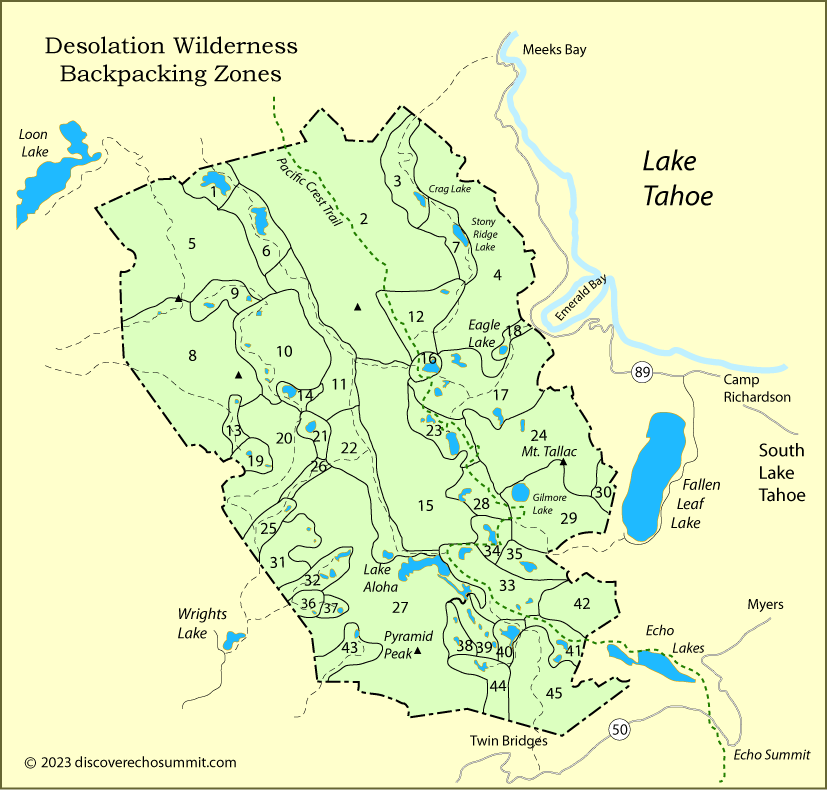
Desolation Wilderness Zones
Rather than trailhead quotas, Desolation Wilderness uses zones.
Permits are issued based on the zone where you will
spend your first night.
Generally the zone numbers begin in the north and work their way south.
Hint: Use the Find feature of your computer to locate the destination you want.
| Zone | Total Daily Entry Quota |
Number that Can Be Reserved |
Popular Destinations in This Zone |
|---|---|---|---|
| When in doubt, confirm your destination with the Forest Service to be sure of the correct zone. | |||
| 1. Rockbound Lake | 25 | 18 | Rockbound Lake |
| 2. General Creek | 10 | 7 | General Creek, Phipps Creek |
| 3. Genevieve | 20 | 14 | Lake Genevieve, Crag Lake |
| 4. Grouse Lakes | 2 | 2 | Grouse Lakes |
| 5. Brown Mountain | 8 | 6 | |
| 6. Rubicon Reservoir | 23 | 14 | Rubicon Reservoir, Rubicon River |
| 7. Stony Ridge | 20 | 14 | Stony Ridge Lake, Meeks Creek |
| 8. Tells | 11 | 8 | Bassi Fork, Forni Lake |
| 9. Highland | 8 | 6 | Highland Lake, Lake Zitella |
| 10. Lelands | 19 | 13 | Horseshoe Lake, McConnell Lake, Leland Lakes, 4 Q Lakes |
| 11. Camper Flat | 20 | 14 | Camper Flat, Northern Rockbound Valley, Rubicon River |
| 12. Phipps | 4 | 2 | Phipps Creek, Phipps Lake |
| 13. Lakes #3 and #5 | 8 | 6 | Lake No. 3, Lake No. 5 |
| 14. Schmidell | 10 | 7 | Lake Schmidell |
| 15. Dick's Peak | 4 | 2 | |
| 16. Middle Velma | 20 | 14 | Middle Velma Lake |
| 17. Lower Velma | 40 | 28 | Upper Velma Lake, Lower Velma Lake, Azure Lake |
| 18. Eagle | 6 | 4 | Eagle Lake |
| 19. Lawrence | 8 | 6 | Lawrence Lake, Top Lake, Lake No. 9 |
| 20. Red Peak | 6 | 4 | |
| 21. Lois | 8 | 6 | Lake Lois |
| 22. China Flat | 12 | 8 | China Flat, Southern Rockbound Valley, Clyde Lake, Rubicon River |
| 23. Dick's | 16 | 11 | Dick's Lake, Fontanillis Lake |
| 24. Kalmia | 6 | 4 | Kalmia Lake, Snow Lake, Tallac Lake |
| 25. Maud | 12 | 8 | Maud Lake, Jones Fork Silver Creek, Willow Flat |
| 26. Rockbound Pass | 6 | 4 | Lake Doris |
| 27. Mt. Price | 12 | 8 | Lake Aloha (west shore), Pyramid Peak, Crystal Range |
| 28. Half Moon | 5 | 3 | Half Moon Lake, Alta Morris Lake |
| 29. Gilmore | 18 | 13 | Gilmore Lake |
| 30. Cathedral | 4 | 2 | Cathedral Lake |
| 31. Tyler | 8 | 6 | Tyler Lake, Gertrude Lake |
| 32. Twin | 20 | 14 | Twin Lakes, Island Lake, Boomerang Lake, Umpa lake |
| 33. Aloha | 36 | 25 | Lake Aloha (east shore), Heather Lake, Lake LeConte, Jabu Lake, Lake Lucille, Lake Margery |
| 34. Susie | 8 | 6 | Susie Lake |
| 35. Grass | 8 | 6 | Grass Lake, Glen Alpine Creek |
| 36. Hemlock | 12 | 8 | Grouse Lake, Hemlock Lake |
| 37. Smith | 5 | 3 | Smith Lake, Secret Lake |
| 38. Waca | 5 | 3 | Waca Lake, Pyramid Lake |
| 39. American | 10 | 7 | American Lake, Channel Lake, Desolation Lake |
| 40. Lake of the Woods | 20 | 14 | Lake of the Woods |
| 41. Tamarack | 20 | 14 | Tamarack Lake, Cagwin Lake, Ralston Lake |
| 42. Triangle | 2 | 2 | Triangle Lake, Lost Lake |
| 43. Lyons | 15 | 10 | Lyons Lake, Lyons Creek, Lake Sylvia |
| 44. Avalanche | 20 | 14 | Ropi Lake, Toem Lake, Osma Lake, Avalanche Lake, Pitt Lake, Pyramid Creek, Horsetail Falls |
| 45. Ralston | 4 | 2 | Ralston Peak |